Technology changes yearly, monthly, weekly, daily it seems in today’s society. The changes range from making dinner a little easier to treating cancer with advanced scanning and dissecting technologies. Technology in fishing seems to be a hot button topic. Absolutely you can catch bass without a single piece of electronics technology in your fishing boat. But put yourself on a 100,000 acre reservoir and breaking down a new body of water can feel more like finding a needle in a stack of needles.
Those of us that grew up using flashers have forced ourselves to interpret what a ring of pulsing light means in terms of fish, cover and forage around us. Then as paper charters came into popularity, it was cool to be able to draw contours on to a roll of scrolling paper. Next entered the liquid crystal displays and we again had to learn that a fish was a shallow tapering arch or saucer on the screen. Moving active fish under a stationary boat were spaghetti lines on the screen.
Now we truly live in the golden age of depth finding technologies. We have available to us side imaging and down imaging technologies, HD sonar that can actually look into cover and see fish. Yet with all this technology available to us, the most requested topic I get from anglers involves interpreting what they see on their sonar, or Down Scan or Side Scan imaging.
We’re going to work on sharing some cool screen shots and then walking through what’s there. No it’s not going to be a bunch of underwater things that never hold fish. It’s going to usually be fish, forage and the cover the fish are relating to during different seasons. The goal will be to provide anglers with the knowledge to be confident when they scan over something that they are seeing what they think they are.
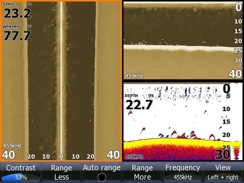
This is the first screen from my Lowrance HDS 8 Gen2 Unit. Now folks will look at this and say they see the bass. It’s a little easier to say that when someone shows you a screen knowing they are going to show you fish. But when you encounter this on the lake you’re looking for the position of the fish on the screen as well the marks and arches.
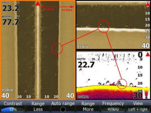
Let’s start however with orientation on the three screens. It’s important to note where your boat is on each of the three screens technologies. We’ve place a red triangle in each pane. That is the current location of your boat on each screen. Always.
The left pane is side imaging. The boat is orientated at the top middle. Now anglers often mistakenly think when they set their side scan area to 40 feet they are scanning out 40 feet to either side. No not really. You’ll notice our depth is around 23 feet. On the ranges on either side the bottom starts being drawn at 23 feet. What you are seeing is directly below the boat on the left and on the right. Then from there it starts scanning out. So really it is scanning out to the “side” roughly 17 feet. The depth alters how far “out to the side” it images. Because it has to look down and then out.
The other thing folks don’t realize is by setting your side scan to a large range, say 100 feet, you’re looking for cover or structure because the bass will be too small, mere specs of sand on the screen. I like to set my range outward about 30-50 feet depending on how deep I’m fishing or looking for schools of bass because I am often looking for the actual fish. Unless I’m looking through open expanses of water searching for isolated pieces of large cover.
In this screen, we see a school of bass hunkered down around the bottom in 23 feet of water on all three screens. I placed 3 circles on the exact same group of fish in each window. Again it’s about perspective.
On the right side I have it split showing down scan and sonar together. One thing to note, and why I often switch to the three screen mode when I’m searching, the side scan screen shows me roughly 28 catchable bass. The sonar shows me about half that. What you often get with side imaging and down imaging is better separation and less masking. Sonar looks downward in a conical spectrum while side imaging and down imaging to a degree look down and outward more as a sheet fed scan, so the way they interpret will be vastly different.
Then as I stop to fish, I often go to straight sonar or sonar and GPS split screen. That’s because Structure Scan needs the boat moving to paint an accurate picture. On the Lowrance units, it actually matches the speed of the scan to the speed of the boat. If you go to slow you get elongated distortion. So I often scan at roughly 4-6 mph.
When I’m not moving, sonar will just constantly echo returns and what you see is a continuous line as it re-pings the same object over and over but the screen is scrolling so the result is a line moving up and down or multiple lines moving up and down instead of a single dot as you pass over quickly with side scan.
Now back to the orientation aspect. Yes I’ve caught a lot of bass suspending, but I’ve caught way more bass that are relating to the bottom or some form of cover. In this picture it’s also good to note the bottom hardness. The Down Scan illustrates a hard bottom.
As you pass from a soft bottom to a hard bottom on side and down scans, the bottom will get much brighter (i.e. a stronger return). Bass in deep water like hard bottoms. When you mark fish positioned on a hard bottom in deep water and they are orientated horizontally along the hard bottom, they are often bass. I don’t like to see short clumps of fish stacked up tall on the screen. Typically that is what white bass, yellow bass, crappie, even species like drum do.
Bass when they are actively corralling bait fish on the bottom will position more horizontally along the bottom over a long space, rather than straight up and down in a small space.
Now size can tip you off to what is on the screen too. IF those arches were larger and appeared almost “hairy” on the screen, they are generally rough fish. For some reason, the denser the fish (or harder the scales like on rough fish) the return almost looks like an arch or spot with hair draping off it. Also notice how much a foot would be if the dark space on the side scan screen on the left has 23 feet in it on either side of center. So I’ve come to realize when I see fish of this size at this 40 foot scale in 20 feet of water, I know they are bass.
Perspective is everything when looking at electronics. If the fish seem too large on a small scale, they probably aren’t what you’re looking for. If they are stacked up tall, again they may not be what you are looking for. But when you see them orientated along the bottom, you’re going to figure out a lot quicker what’s going on down there under and out to the side of your boat.
We’ll work more on sonar, some of the settings to help you get the most out of your units in our next installment of Fishing Technology and feel free to send us suggestions on what you want to see.
If you liked this, you’ll probably like these two articles on finding and catching suspending fish with sonar and imaging:


